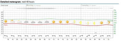
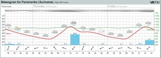
Meteogram
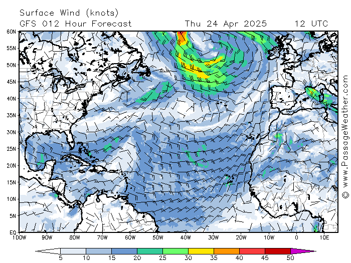
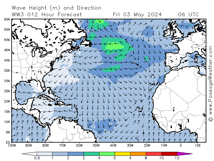
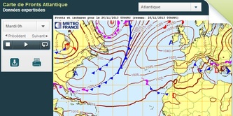
Actueel - Wind North Atlantic
VOlvo Ocean Race vanaf zuid-Afrika naar Dubai e.v.
De site van de race zelf vind je hier.
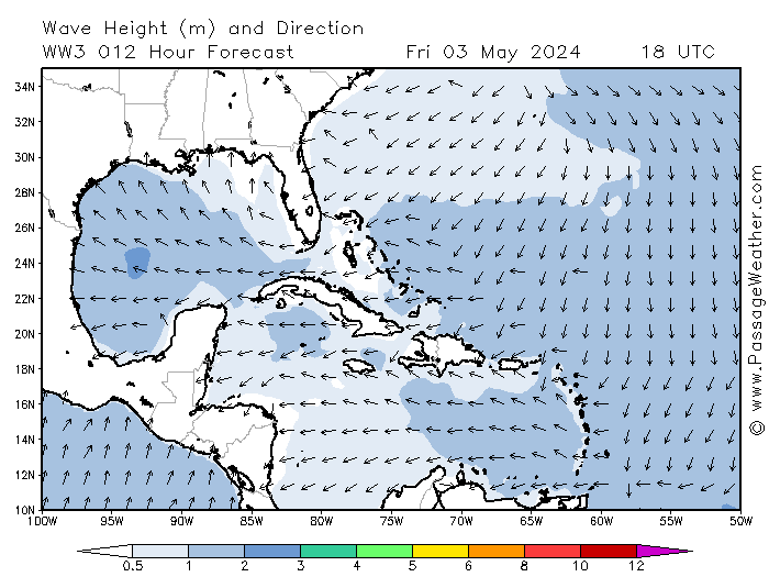
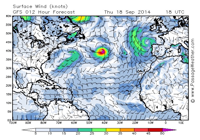
Zie verwachting op PassageWeather.


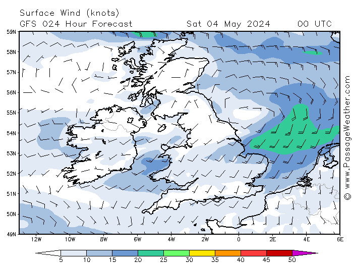
Actueel - Golven rond Engeland
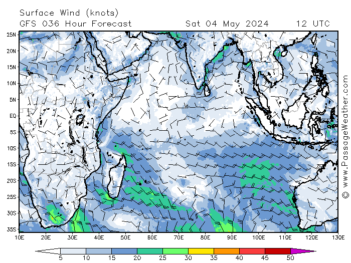
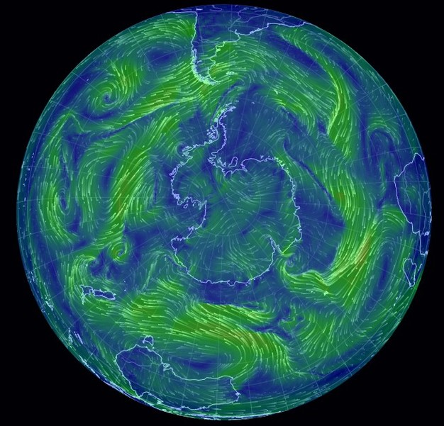
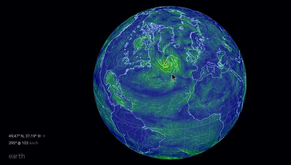
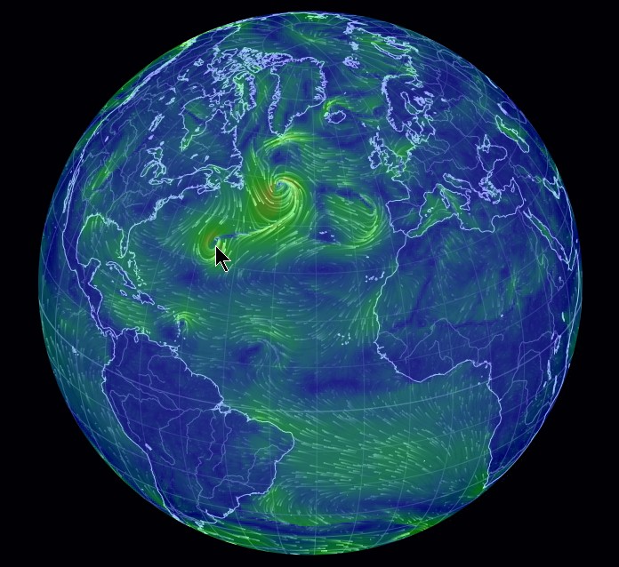
Luchtstromen
Klik op de wereldbol voor een actuele animatie.
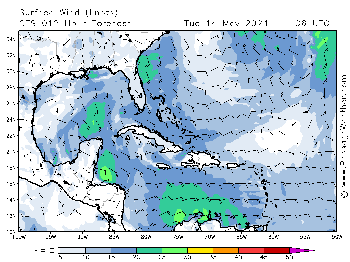
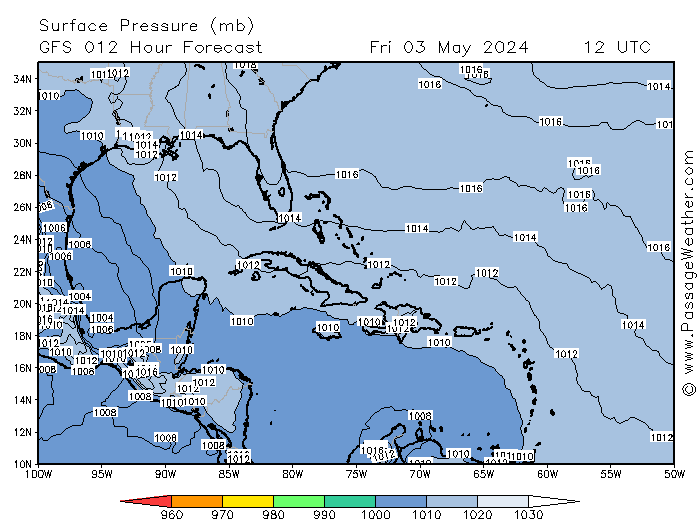
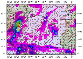
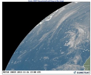
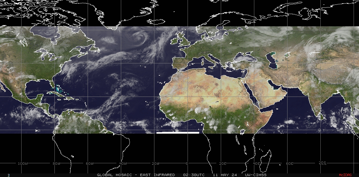
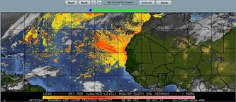
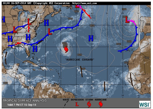
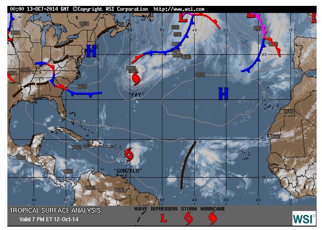
fronten en neerslag - Caribic


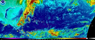
Satellietfilm van dit gebied.
De Cabo's Verde zijn de stipjes in het zwarte gebied rechts net 'buiten beeld', Suriname ligt midden onder.
Goed te zien is dat daartussen de bovenwind naar het NO,
en de oppervlaktewind (passaat) ter compensatie naar het ZW waait. Zie Hadleycel.
De Cabo's Verde zijn de stipjes in het zwarte gebied rechts net 'buiten beeld', Suriname ligt midden onder.
Goed te zien is dat daartussen de bovenwind naar het NO,
en de oppervlaktewind (passaat) ter compensatie naar het ZW waait. Zie Hadleycel.

Meteosites
www.windfinder.com
Wind en weer wereldwijd, weerkaarten en getijden.
Wereldbeeld luchtstromen op Earth
Passageweather
PassageWeather.com specialises in Sailing Weather Forecasts, and was developed out of the need for reliable, easy to use weather information... We provide 7-day Wind, Wave and Weather Forecasts to help sailors with their passage planning and weather routing.
Both before and during deliveries, ocean races, regattas, cruises and all other types of offshore passages, we have your whole route covered.
Our Weather Data The weather data that we use to produce our weather forecast charts come from the most trusted and reliable sources available. These sources include the US National Weather Service (NWS), the National Oceanic and Atmospheric Administration (NOAA), the National Centers for Environmental Prediction (NCEP), the Marine Meteorology Division of the U.S. Naval Research Laboratory (NRL), Sailing Weather Service (SWS) and the Cyprus Oceanography Center (COC).
Atlantic Hurricanes timelapse
This digital animation of the 2009 Atlantic hurricane season displays NOAA's NCEP half-hourly compilation of infrared cloud imagery over hurricane alley from the geosynchronous weather satellites, principally from NOAA's GOES-12 at 75W.
Credit: NOAA-NASA GOES Project
TROPMET
TROPMET.COM is a website dedicated to hurricanes, tropical cyclones, tropical meteorology, severe weather and storm-chasing, is owned and solely maintained by veteran storm chaser, Michael Laca.
TROPMET.COM is the evolution of a company (Tropmet, Inc.) that was founded and incorporated by Michael Laca in 1991. The purpose of this company is to provide services and disseminate information on tropical cyclones and other forms of severe weather, to the public, as quickly as possible.
Storm-Carib site
Deze site is niet actief tot 1 juni vanwege het (normaal) ontbreken van hurricanes tot die tijd. De gekozen namen van de lieverdjes in 2013 zijn bekend: Andrea | Barry | Chantal | Dorian | Erin | Fernand | Gabrielle | Humberto | Ingrid | Jerry | Karen | Lorenzo | Melissa | Nestor | Olga | Pablo | Rebekah | Sebastien | Tanya | Van | Wendy |. Tot en met Lorenzo hebben we ze gehad.
Orkanen hebben de neiging te ontstaan wanneer het zeegebied tussen Cabo Verde en de Carib ietsje warmer is dan normaal en de passaatwinden ietsje harder waaien. Dan gaat er in de lucht iets horizontaal wervelen en al gauw verticaal. Condenserend vocht daarin maakt bij het opstijgen warmte vrij: dat is weer brandstof voor nog meer actie. Advies: minstens een stormfok of een goed anker mee als je dit op zee overkomt.
De namen voor 2014 hebben we gevonden (elke zeven jaar dezelfde namenserie) in de Engelse Wikipedia:
Een aardig fok-forum over orkanen vind je hier. Zelfs in de Golf van Biskaye kan het goed spoken.
Meteorologica
Overzicht van het weer rond Engeland en op de Atlantische Oceaan tot aan de Canarische Eilanden. Actualisering elk uur.
yr.no
Meteo-instituut van Noorwegen, verzamelt data van andere weerstations, goede voorspellingen.
Windguru
The windguru.cz / windguru.com provides weather forecasts based on numeric models and other related information, especially for windsurfing, kitesurfing, yachting and other sporting activities.
Grib.us
Grib is the format used by the meteorological institutes of the world to transport and manipulate weather data and is the foundation of the forecasts we see around us in our daily life. In the past, accessing and viewing GRIB weather data has often required a tricky combination of technical knowledge and expensive
software. Now there's GRIB.US. A company that empowers you, the end-user, to interactively extract your own custom GRIB weather files tailored to your needs. We also provide you with our - easy to use- Ugrib software to view this data so that you can look at weather data for anywhere in the world when you want to, where you want to. Best of all, this is all for FREE!
Rasp.stratus.org.uk
Site voor zweefvliegers, geeft een beeld van dwarsdoorsneden van de atmosfeer (vocht, oppervlaktewind, weersystemen, wetenschappelijk, met dag-animaties, goed bruikbaar voor zeilers).
Pacific Disaster Center
Pacific Disaster Center (PDC) is an applied science, information and technology center, working to reduce disaster risks and impacts to peoples' lives and property. Voor het geval we besluiten het Panamakanaal te gebruiken en de andere grote plas over te steken zodat we via de Filipijnen en het Suezkanaal kunnen terugkeren, bij Somalië gedekt door Moedige Hollandse Marineboys.
Tropische cyclonen
The main questions facing tropical cyclone (TC) forecasters are accurately determining the current intensity of the storm, the future intensity of the storm, and where the storm will be in the future. Data obtained from satellites are ideal for helping to provide answers to these questions due to their ability to provide nearly constant and total coverage of the tropics in space and time. The CIMSS Tropical Cyclone webpage helps achieve these goals by providing near real-time imagery, derived atmospheric analysis products, and TC intensity estimates from a variety of different satellite platforms for global analysis of TCs and their surrounding environments. Many of the products from CIMSS are developed specifically for use by TC forecasters worldwide to provide unique information in support of their specific TC forecasting missions.
The CIMSS Tropical Cyclone group does not produce forecasts or warnings for any TCs, instead we provide unique information to the organizations and forecasters who do.
Andere weerkaarten
Wind en weer wereldwijd, weerkaarten en getijden.
- Spain - Meteogram Gran Canaria
- Atlantische Oceaan - satellietfilm infrarood wolken boven Afrika
- Europa - satellietfilm
- Europa - satellietfilm InfraRood
Wereldbeeld luchtstromen op Earth
Passageweather
PassageWeather.com specialises in Sailing Weather Forecasts, and was developed out of the need for reliable, easy to use weather information... We provide 7-day Wind, Wave and Weather Forecasts to help sailors with their passage planning and weather routing.
Both before and during deliveries, ocean races, regattas, cruises and all other types of offshore passages, we have your whole route covered.
Our Weather Data The weather data that we use to produce our weather forecast charts come from the most trusted and reliable sources available. These sources include the US National Weather Service (NWS), the National Oceanic and Atmospheric Administration (NOAA), the National Centers for Environmental Prediction (NCEP), the Marine Meteorology Division of the U.S. Naval Research Laboratory (NRL), Sailing Weather Service (SWS) and the Cyprus Oceanography Center (COC).
Atlantic Hurricanes timelapse
This digital animation of the 2009 Atlantic hurricane season displays NOAA's NCEP half-hourly compilation of infrared cloud imagery over hurricane alley from the geosynchronous weather satellites, principally from NOAA's GOES-12 at 75W.
Credit: NOAA-NASA GOES Project
TROPMET
TROPMET.COM is a website dedicated to hurricanes, tropical cyclones, tropical meteorology, severe weather and storm-chasing, is owned and solely maintained by veteran storm chaser, Michael Laca.
TROPMET.COM is the evolution of a company (Tropmet, Inc.) that was founded and incorporated by Michael Laca in 1991. The purpose of this company is to provide services and disseminate information on tropical cyclones and other forms of severe weather, to the public, as quickly as possible.
Storm-Carib site
Deze site is niet actief tot 1 juni vanwege het (normaal) ontbreken van hurricanes tot die tijd. De gekozen namen van de lieverdjes in 2013 zijn bekend: Andrea | Barry | Chantal | Dorian | Erin | Fernand | Gabrielle | Humberto | Ingrid | Jerry | Karen | Lorenzo | Melissa | Nestor | Olga | Pablo | Rebekah | Sebastien | Tanya | Van | Wendy |. Tot en met Lorenzo hebben we ze gehad.
Orkanen hebben de neiging te ontstaan wanneer het zeegebied tussen Cabo Verde en de Carib ietsje warmer is dan normaal en de passaatwinden ietsje harder waaien. Dan gaat er in de lucht iets horizontaal wervelen en al gauw verticaal. Condenserend vocht daarin maakt bij het opstijgen warmte vrij: dat is weer brandstof voor nog meer actie. Advies: minstens een stormfok of een goed anker mee als je dit op zee overkomt.
De namen voor 2014 hebben we gevonden (elke zeven jaar dezelfde namenserie) in de Engelse Wikipedia:
- Arthur (20140701 bij Florida, zie routeinfo etappe 8)
- Bertha (20140731 Stormdepressie)
- Cristobal (20140825 Hurricane, van Florida 100 mijl uit de kust langs New York, geen landschade)
- Dolly (20140902 in de Golf van Mexico)
- Edouard (20140916 North Atlantic, op 20140918)
- Fay (20141012) op 20141013
- Gonzalo (20141013)
- Hanna (unused)
- Isaias (unused)
- Josephine (unused)
- Kyle (unused)
- Laura (unused)
- Marco (unused)
- Nana (unused)
- Omar (unused)
- Paulette (unused)
- Rene (unused)
- Sally (unused)
- Teddy (unused)
- Vicky (unused)
- Wilfred (unused)
Een aardig fok-forum over orkanen vind je hier. Zelfs in de Golf van Biskaye kan het goed spoken.
Meteorologica
Overzicht van het weer rond Engeland en op de Atlantische Oceaan tot aan de Canarische Eilanden. Actualisering elk uur.
yr.no
Meteo-instituut van Noorwegen, verzamelt data van andere weerstations, goede voorspellingen.
Windguru
The windguru.cz / windguru.com provides weather forecasts based on numeric models and other related information, especially for windsurfing, kitesurfing, yachting and other sporting activities.
Grib.us
Grib is the format used by the meteorological institutes of the world to transport and manipulate weather data and is the foundation of the forecasts we see around us in our daily life. In the past, accessing and viewing GRIB weather data has often required a tricky combination of technical knowledge and expensive
software. Now there's GRIB.US. A company that empowers you, the end-user, to interactively extract your own custom GRIB weather files tailored to your needs. We also provide you with our - easy to use- Ugrib software to view this data so that you can look at weather data for anywhere in the world when you want to, where you want to. Best of all, this is all for FREE!
Rasp.stratus.org.uk
Site voor zweefvliegers, geeft een beeld van dwarsdoorsneden van de atmosfeer (vocht, oppervlaktewind, weersystemen, wetenschappelijk, met dag-animaties, goed bruikbaar voor zeilers).
Pacific Disaster Center
Pacific Disaster Center (PDC) is an applied science, information and technology center, working to reduce disaster risks and impacts to peoples' lives and property. Voor het geval we besluiten het Panamakanaal te gebruiken en de andere grote plas over te steken zodat we via de Filipijnen en het Suezkanaal kunnen terugkeren, bij Somalië gedekt door Moedige Hollandse Marineboys.
Tropische cyclonen
The main questions facing tropical cyclone (TC) forecasters are accurately determining the current intensity of the storm, the future intensity of the storm, and where the storm will be in the future. Data obtained from satellites are ideal for helping to provide answers to these questions due to their ability to provide nearly constant and total coverage of the tropics in space and time. The CIMSS Tropical Cyclone webpage helps achieve these goals by providing near real-time imagery, derived atmospheric analysis products, and TC intensity estimates from a variety of different satellite platforms for global analysis of TCs and their surrounding environments. Many of the products from CIMSS are developed specifically for use by TC forecasters worldwide to provide unique information in support of their specific TC forecasting missions.
The CIMSS Tropical Cyclone group does not produce forecasts or warnings for any TCs, instead we provide unique information to the organizations and forecasters who do.
Andere weerkaarten
- RASP Animatie wind boven Nederland morgen
- RASP dwarsdoorsnedes Nederlands luchtgebied
- Engeland - Inshore Waters Forecast and Strong Winds
- MetOffice UK/Sea Marine
- KNMI - waarschuwingen_en_verwachtingen
- Belgie - Zee en kustweerbericht
- Scheepsweerbericht Noordzee
- Atlantische oceaan fronten
- Atlantische oceaan - Shipping forecast and gale warnings
- USA
- North Atlantic Hurricane zone
- Luchtstromen boven North Atlantic
- Oost Noord Atlantic Afrika - humidity
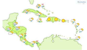
METEO CARIBIC morgen
Meteo Noord Atlantic - Plaatjes


Meteo Noord Atlantic - Animaties


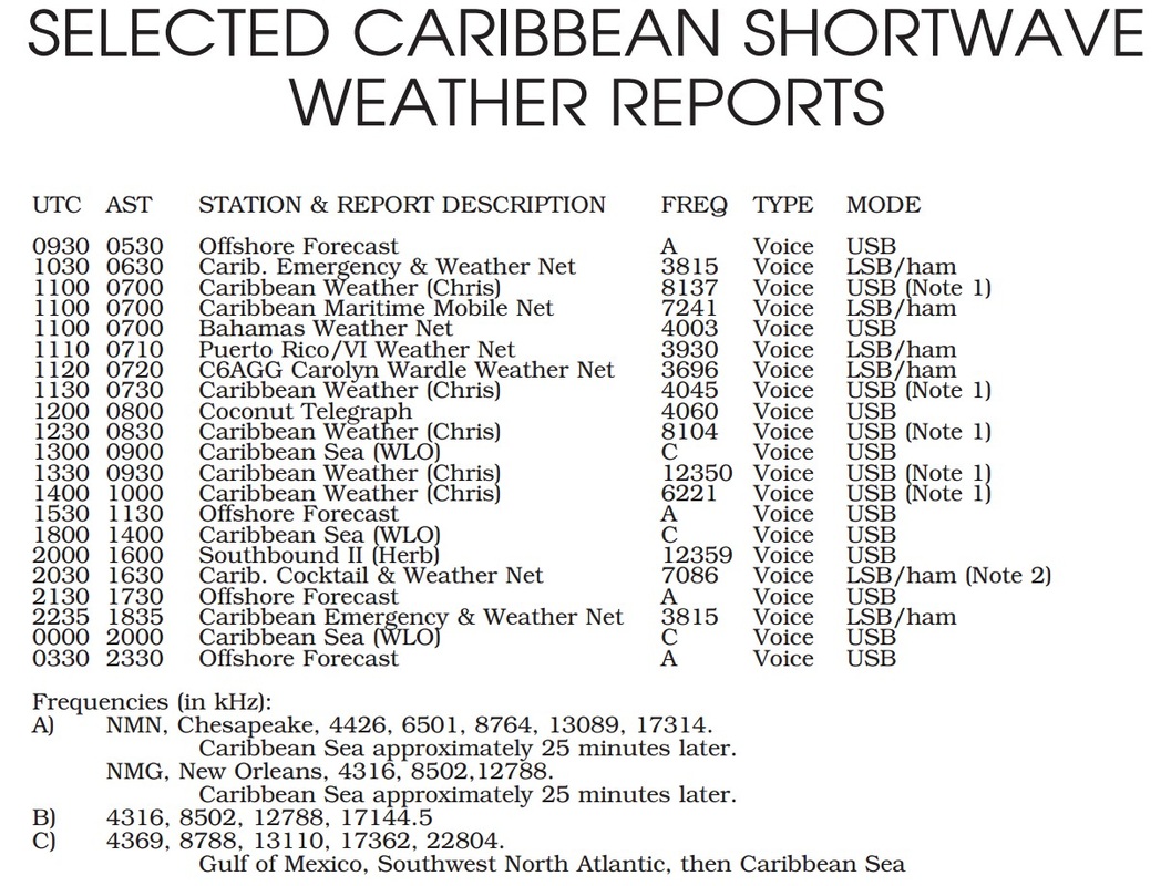
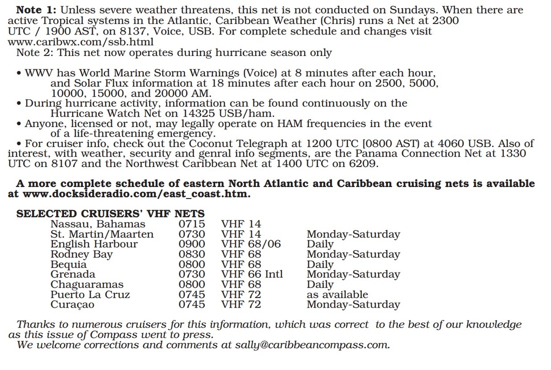
Gesproken weerberichten Caribic via de SSB
Naar startpagina
